No matching chapters. Try another term or clear the search.
FIELD MANUAL / 01
Your first patrol
Take a quiet patrol before a combat scenario. Learn the helm, the chart and the boat’s response to an order.
- Launch your supplied beta build. Use the same build as the other players if you intend to join a cooperative patrol.
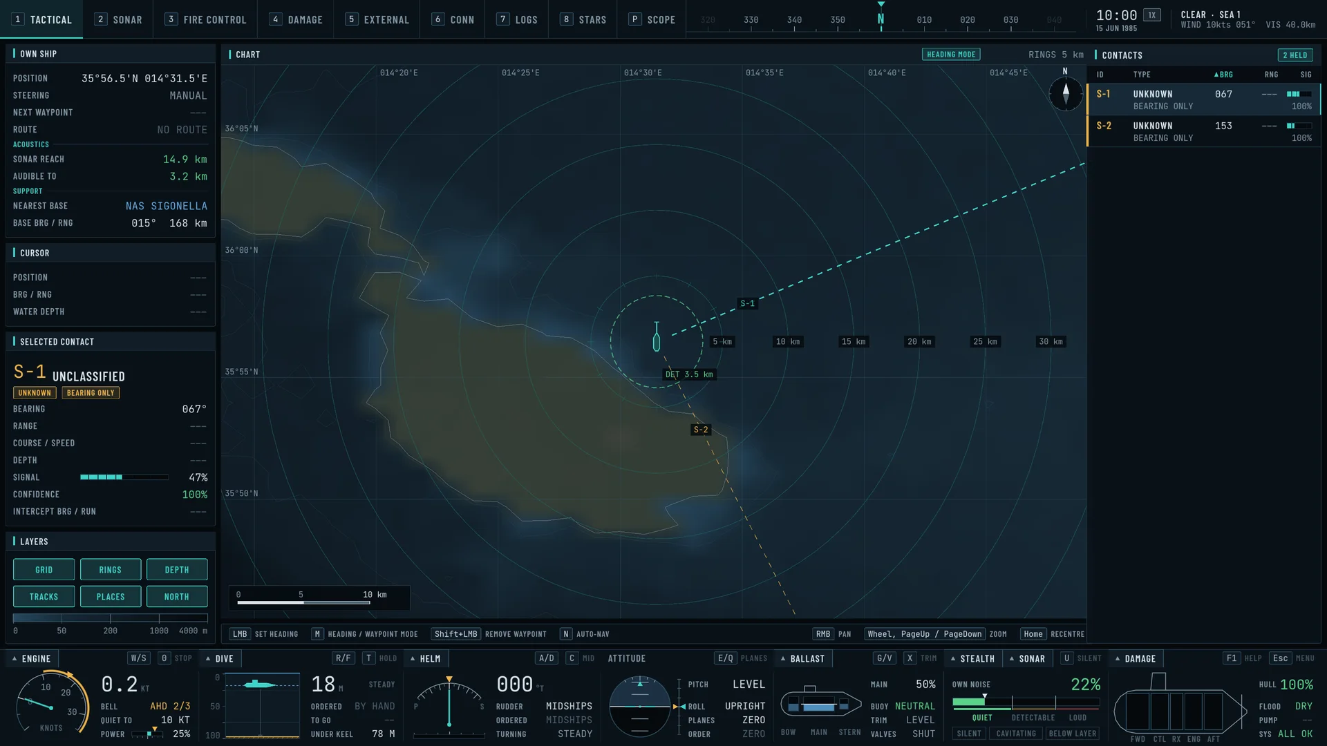
- Open the tactical chart with 1. Check your position and surroundings before setting off.
- Add power gradually with W. Reduce it with S. Watch the speed and depth instruments as the boat responds.
- Visit the stations. Use the number keys or the station bar. Tab cycles views; the periscope is skipped when its mast is lowered.
- Try a short passage. Open Trip planner from the title or pause menu. Review the route on the tactical chart before using it.
FIELD MANUAL / 02
Helm & boat controls
These are the default bindings in the current build. Remapping in Controls changes the game’s hints; this reference remains a list of defaults.
| Key | Order |
|---|---|
| W / S | Increase / decrease throttle |
| A / D | Rudder left / right |
| C | Rudder amidships |
| 0 | All stop |
| E / Q | Manual depth up / down |
| R / F | Auto-depth target shallower / deeper |
| T | Toggle auto-depth |
| N | Toggle automatic navigation |
| G / V | Blow / flood ballast |
| Shift + G | Emergency blow |
| X | Neutralize trim |
| Shift + P | Order periscope depth |
| P | Raise the periscope and enter its view, or lower it |
| U | Toggle silent running |
| Esc | Open the pause menu |
An order is not an instantaneous change of position or speed. Leave time and clearance for the boat to respond. Automatic navigation is a separate command; transferring a route from the planner does not turn it on.
FIELD MANUAL / 03
Your stations
The overhaul organizes the boat around dedicated stations. Choose one from the station bar or use its default shortcut.
| Key | Station | Use it to |
|---|---|---|
| 1 | Tactical | Review contacts, position, terrain and waypoints. |
| 2 | Sonar | Listen, classify contacts and develop tracks. |
| 3 | Fire control | Review the firing solution and manage weapon tubes. |
| 4 | Damage control | Inspect flooding, damage, pumps and repairs. |
| 5 | External | Observe the boat and the surrounding sea. |
| 6 | Conn | Work the boat’s instruments and orders. |
| 7 | Logs | Review crew reports and event history. |
| 8 | Stars | Look at and identify the night sky. |
| P | Periscope | Raise or lower the mast and use the optical view. |
| Tab | Cycle views | Move through stations; lowered periscope is skipped. |
FIELD MANUAL / 04
Contacts, weapons & damage
Build a picture before committing.
Start with sonar. Passive listening, active sonar, narrowband analysis and target-motion tools help you develop a contact. Radar and ESM provide other observations when their operating conditions allow.
| Key | Action |
|---|---|
| Y | Active sonar ping |
| Shift + Y | Toggle active search |
| Z | Toggle towed array |
| J | Toggle radar |
| I | Toggle ESM |
Move to fire control.
Select and review the target, prepare your tubes and follow the station’s firing controls. The simulation includes torpedoes, wire guidance, countermeasures, depth charges and mines. Weapon behaviour depends on the equipped type and current scenario.
Keep the boat fighting.
Damage control shows hull and system damage, compartment flooding, pumps and repair assignments. Pay attention to crew reports and revisit your depth and speed after taking damage.
FIELD MANUAL / 06
Buoys, beacons & lighthouses
The bundled OpenStreetMap snapshot contains 204,128 navigation aids: 95,422 buoys, 66,494 beacons, 14,952 lighthouse records and 27,260 other lights.
Nearby aids appear as generic 3D models. Buoys follow ocean height near the camera. Fixed lights use supported published sequences, sector limits and ranges, with visibility affected by night and atmospheric haze.
On the tactical chart, enable Places and zoom to 100 m/pixel or closer. Hover a marker for its name, coordinates, source tags and OpenStreetMap identity.
FIELD MANUAL / 07
Night sky & star identification
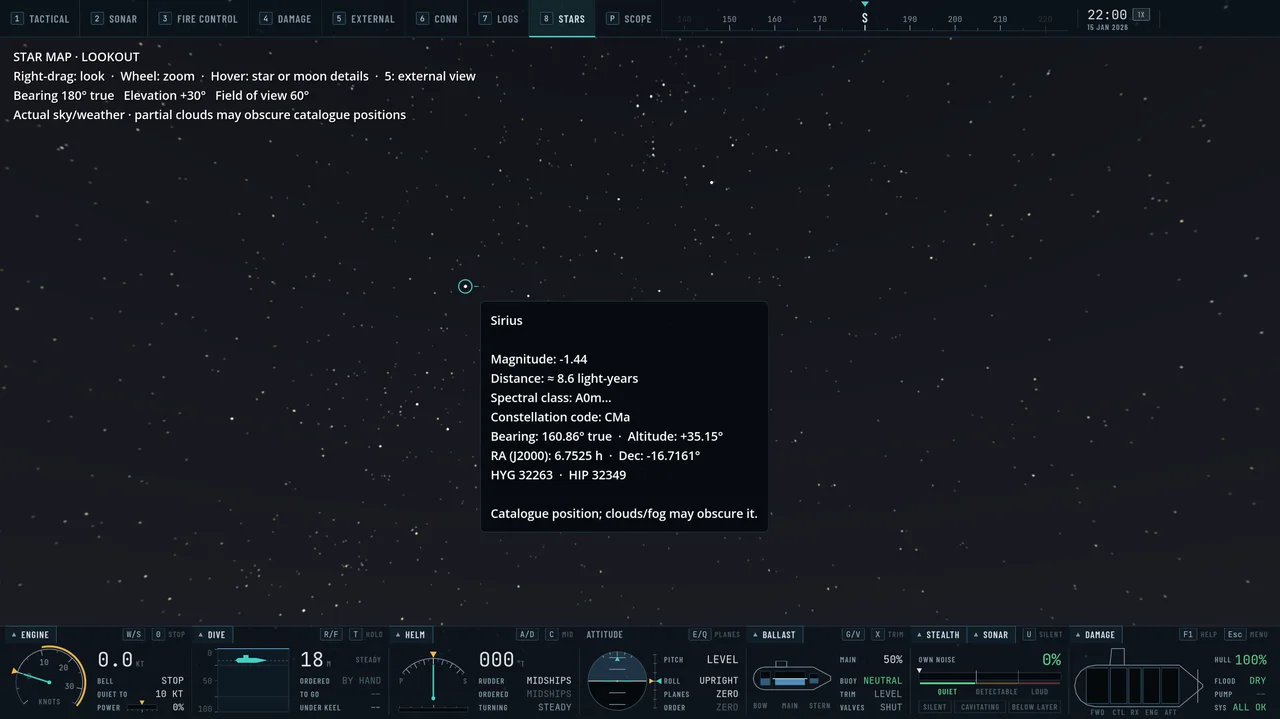
Press 8 or choose Stars to enter a first-person lookout from the submarine’s position. The sky follows your location, game date and time, including the Moon’s phase.
- Hold the right mouse button and drag to look around.
- Scroll to zoom, then release the mouse button and hover near a star.
- Read the catalogue name or ID, magnitude, approximate distance, spectral class, constellation, bearing and altitude where available.
- After dusk and before dawn, watch for satellites: steady points crossing the stars, the space stations and spy satellites among them. Hover one for its name, type, height and the direction it is crossing. Their orbits are realistic, but they are not where the real satellites are tonight.
- Select another station to return to the boat’s other views.
The lookout uses actual sky and weather conditions. It does not clear clouds, change time or bypass submergence. Identification is disabled underwater, in daylight or under nearly complete overcast; twilight reduces the available stars.
FIELD MANUAL / 08
Traffic, weather & offline play
Simulated maritime traffic has trip intent. Merchant traffic follows routes; coastal populations include small craft and vessels waiting at suitable offshore anchorages. Anchored ships can depart again after a layover.
Season and weather influence local small-craft activity. Weather changes the sky, visibility and sea state, while nearby buoys and vessel motion respond to the ocean.
The beta works without live feeds.
Normal beta play uses simulated traffic and bundled navigation data. No AISStream key is required or included. The separate development Live World integration can consume AIS and weather feeds through a relay; that is not part of the offline beta setup.
A simulated trip is not a global commercial voyage reconstruction. Regional traffic uses local route checks rather than a worldwide port-to-port routing engine. Where live AIS is used in development, missing origins and destinations are not invented.
FIELD MANUAL / 09
Cooperative free patrol
Up to four players can take separate submarines into one free patrol. The host shares traffic, weather, date and time; each player commands their own boat.
- Use the same game build on every machine.
- Open Multiplayer from the title or pause menu.
- One player chooses Host patrol. Up to three others enter the host’s address and choose Join patrol.
- For internet hosting, the host must be reachable on the configured port (default UDP 7777). This commonly requires router port forwarding. LAN play needs no rented server.
- Leave through Multiplayer or return to the main menu. Losing the host ends the session.
FIELD MANUAL / 10
Saving & returning to a patrol
Use Esc → Save checkpoint. Load from the pause menu or choose Continue checkpoint on the title screen. Loading replaces the current session after confirmation and leaves the game paused until you resume.
There is one checkpoint slot. Supported saves restore the boat’s physical state and orders, weather and time, waypoints, supported mission progress, actor routes, civilian trip plans, damage and weapon inventory.
Save before the encounter.
Quiet single-player patrols and supported mission states can be saved. Active weapons, mines, countermeasures, sensor histories, sinking actors and some other transient states prevent checkpointing. Multiplayer, Live World and unsupported vessel states are also excluded. The menu tells you the reason and preserves the previous save.
FIELD MANUAL / 11
Beta notes & useful reports
The current focus is improving the sea, atmosphere, world detail and tactical experience while expanding the scope of cooperative play. Features and visual presentation may change between builds.
When reporting a problem
- Press F12, or choose Report a problem in the pause or title menu. The game saves one zip file holding the build number, your system and graphics settings, a screenshot, the game log and a checkpoint, and shows you where the file is. Nothing is sent anywhere; you post the file yourself.
- Say what you did, what happened and what you expected. The file already records where you were, the station, the weather and the sea state.
- Say whether you were in single-player or co-op, and whether you were the host or a client.
- Post the file in #bug-reports on the Veiled Depths Discord ↗, one thread per problem.
There is no public download or signup service attached to this website. Existing testers should use their established distribution and feedback channel.
FIELD MANUAL / 12
Credits & world data
Veiled Depths is developed by David Balzan, with sailing and surface-vessel dynamics contributions from gorlitzer. Built with the Godot Engine. The in-game Credits screen contains the wider asset and contributor list.
- Terrain: NOAA ETOPO 2022 global relief data.
- Seabed, European seas: EMODnet Digital Bathymetry (DTM 2024), EMODnet Bathymetry Consortium. This data product was created by EMODnet and is owned by the EU; CC BY 4.0, doi:10.12770/cf51df64.
- Seabed, Norwegian waters: Kartverket (Norwegian Mapping Authority), Dybdedata - terrengmodeller 50 meters grid, CC BY 4.0.
- Seabed, the Arctic: The International Bathymetric Chart of the Arctic Ocean (IBCAO) Version 5.2, IBCAO Version 5.2 Compilation Group (2026), NERC British Oceanographic Data Centre. Contains public sector information licensed under the Open Government Licence v3.0.
- Navigation aids: © OpenStreetMap contributors, via the OpenSeaMap-vector extract. Database licensed under ODbL 1.0.
- Ports: NGA World Port Index data reproduced through NOAA’s PIRO Digital Atlas.
- Airfields: OurAirports community data, public domain.
- Stars: HYG catalogue v4.1, CC BY-SA 4.0. The game includes source attribution and catalogue licensing.
- Moon: NASA Lunar Reconnaissance Orbiter imagery.
- Website typefaces: Barlow / Barlow Condensed and JetBrains Mono, under the SIL Open Font License. Barlow license · JetBrains Mono license.
Website images are actual in-engine development captures, resized and compressed for the web. They are not concept art. All game data is supplied for simulation; geographical coverage and currency vary.